


LE PERREON en Beaujolais

JacouBrijou
User
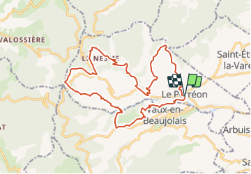

Length
20 km

Max alt
753 m

Uphill gradient
890 m
Km-Effort
32 km

Min alt
284 m

Downhill gradient
890 m
Boucle
Yes
Creation date :
2021-10-12 21:09:29.063
Updated on :
2021-10-12 21:11:59.487
7h14
Difficulty : Very difficult

FREE GPS app for hiking
 SityTrail
IGN / Geographical institutes
SityTrail Plus
The world is yours!
About
Trail Walking of 20 km to be discovered at Auvergne-Rhône-Alpes, Rhône, Le Perréon. This trail is proposed by JacouBrijou.
Positioning
Country:
France
Region :
Auvergne-Rhône-Alpes
Department/Province :
Rhône
Municipality :
Le Perréon
Location:
Unknown
Start:(Dec)
Start:(UTM)
623806 ; 5102268 (31T) N.
Comments